
Imagine this! Every doorstep in India – from that tiny apartment in a bustling city to the haveli in a remote village – pinpointed to a precise 4×4 meter square.
That’s the promise of DIGIPIN (Digital Postal Index Number), which was launched by India Post in May 2025.
Developed with IIT Hyderabad and ISRO‘s National Remote Sensing Centre, DIGIPIN brings GPS-level precision to India’s postal network, augmenting the six-digit PIN codes from 1972.
All About DIGIPIN – What it is and How it Work
DIGIPIN is your location’s unique digital fingerprint. This open-source system converts GPS coordinates into a simple 10-character code, identifying one specific 4×4 meter square anywhere in India – even offshore.
It is unique and privacy-focused, while also accurate.
India Post overlaid a precise digital grid across the country – an open algorithm converting GPS coordinates into a simple 10-character code for each 4x4m square.
The code’s precision depends on your device’s GPS during generation, but the conversion is consistent (same spot, same code). Crucially: Anyone can generate or decode a DIGIPIN offline, perfect for remote areas
Additionally, while creating DIGIPIN, attention was also paid to privacy. DIGIPIN stores only location coordinates – no names, phone numbers, or personal details. Share it publicly without concern. So your privacy is maintained.
Why DIGIPIN Matters:
- Deliveries: Drivers find your exact door.
- Emergencies: Ambulances reach your building entrance faster.
- Rural Areas: Villages without house numbers gain digital addresses.
- Utility Services: Precise location for meter readers/tax collectors.
- Meeting Friends: Share a code instead of complex directions.
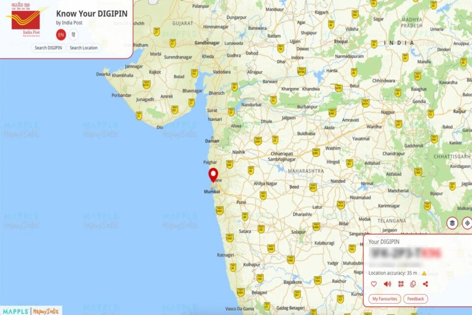
How To Get Your DIGIPIN:
- Visit dac.indiapost.gov.in/mydigipin.
- Share your GPS location or enter coordinates manually.
- Verify the map pin placement.
- Your 10-character DIGIPIN appears. Save it securely.
A mobile app is coming soon, and bulk tools for businesses will be on GitHub.
The Future of PIN Codes?
The familiar six-digit PINs aren’t going away. They’ll still handle broader mail routing. DIGIPIN adds an additional layer of precision to the traditional manual Pincode, making it particularly beneficial for services like emergency responses. Both systems function harmoniously together.
PIN Code vs DIGIPIN: A Complete Comparison
| Feature | PIN Code | DIGIPIN |
|---|---|---|
| Format | 6-digit numeric code | 10-character alphanumeric code |
| Launch Year | 1972 | 2025 |
| Coverage Area | Entire neighborhood/village/large area | Precise 4×4 meter square |
| Precision Level | Area-wide (broad) | Building/doorstep specific (precise) |
| Technology Base | Manual postal sorting | GPS coordinates + digital grid |
| Data Source | Postal administrative boundaries | Satellite mapping + GPS |
| Internet Dependency | Not applicable | No internet needed for generation |
| Open Source | No | Yes (publicly available algorithm) |
| Privacy | Linked to postal addresses | Only location coordinates, no personal data |
| Primary Use | Mail routing and sorting | Digital navigation and precision delivery |
| Future Compatibility | Manual systems | GPS apps, drones, automated systems |
| Rural Coverage | May not cover all areas precisely | Covers every square meter of India |
| Ambiguity Issues | Common (duplicate names, missing numbers) | Eliminated (coordinate-based) |
| Cost | Free | Free |
| Replacement Status | Will continue alongside DIGIPIN | Complements PIN codes, doesn’t replace |
| Best For | Traditional mail delivery | E-commerce, emergency services, ride-sharing |
The Bottom Line
DIGIPIN offers a free, open, and private digital address for any location in India. Including it in your address ensures smoother deliveries and easier connections. Get yours today!
Frequently Asked Questions
What is DIGIPIN?
DIGIPIN is an open source nationwide geo-coded addressing system developed by the Department of Posts in collaboration with IIT Hyderabad and NRSC, ISRO. It divides India into approx. 4m x 4m grids and assigns each grid a unique 10-character alphanumeric code based on latitude and longitude coordinates.
How is DIGIPIN different from a regular postal address?
While a regular postal address depends on locality, street, and house numbers, DIGIPIN is a geospatial reference using a 10-character alphanumeric code based on the exact coordinates of a location.
Why do we need DIGIPIN when we already have postal addresses?
DIGIPIN simplifies address management by providing precise location-based identification, especially in areas with unstructured or changing addresses. It also helps in areas where no clear address exists, such as rural regions, forests, and oceans.
Is DIGIPIN available offline?
Yes, DIGIPIN is designed to be used offline too. Department of Posts have shared the programming code for DIGIPIN logic in public domain for fetching and decoding the DIGIPIN.
Will DIGIPIN affect my privacy?
No, DIGIPIN does not compromise privacy. It only refers to a geographic location and does not store or display personal information linked to that location.
How do I fetch or decode a DIGIPIN?
A DIGIPIN code is a 10-character alphanumeric sequence. It’s a pure function of your location’s latitude and longitude, making it unique for each approx. 4m x 4m area. Department of Posts is planning to share the programming code for DIGIPIN logic in public domain for fetching and decoding the DIGIPIN.
Is my personal address data stored in DIGIPIN?
No, DIGIPIN does not store any private or personal data. It only provides an alphanumeric code based on geographic coordinates, ensuring privacy.
How can businesses benefit from DIGIPIN?
Businesses can use DIGIPIN to improve delivery accuracy, logistics, service coverage, and customer service, especially in areas with complex addresses.